Wanderlusting the Dome Road
Sometimes the wanderlust really gets the better of me, and I end up improvising a trip into the hills. This was one of those times.
I was in Albuquerque Saturday and finished up around 2:00. I had vague plans to visit the Veterans Memorial Lookout at Kashe-Katuwe Tent Rocks National Monument, which I did not have time for during my last visit there, and then maybe double back and drive into the Jemez to a particular rock outcropping I’ve been wanting to inspect for some time.
I ended up improvising instead.
Veterans’ Memorial Scenic Overlook
This is located on the south rim of Camada Canyon and overlooks spectacular scenery to the north, where several canyons converge in an area underlain by Peralta Tuff.
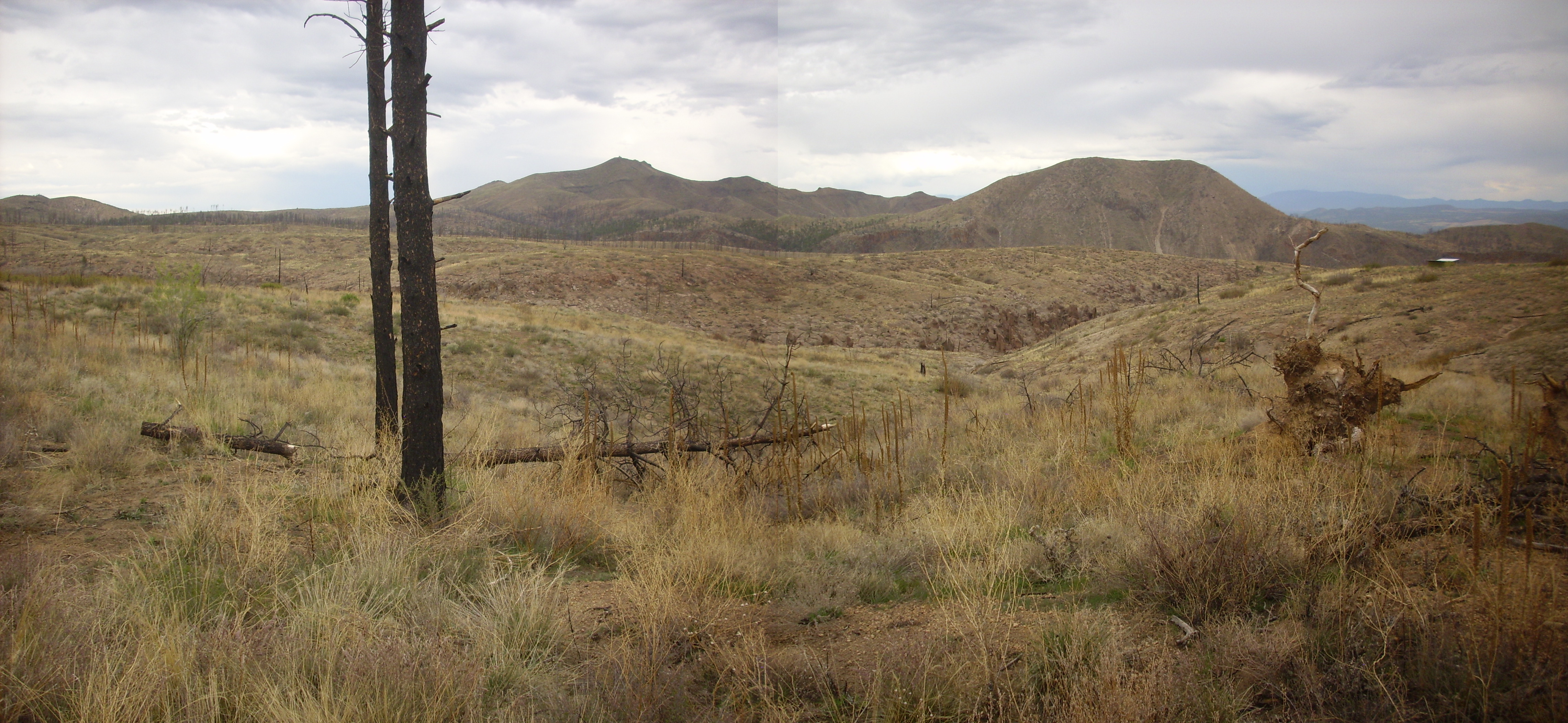
Panorama from Veteran’s Memorial Scenic Overlook. 35 40.398N 106 27.162W
The peak near the center of the second frame is Bearhead Peak, a major eruptive center of the Bearhead Rhyolite. The Bearhead Rhyolite is about 6.5 to 7 million years old and is typically found erupting through the Paliza Canyon Formation, a mostly andesite formation that is typically 8 million years old or older in this area. Bearhead Peak is one of the vents that erupted the Peralta Tuff that makes up the spectacular tent rocks and layered tuffs of Kashe-Katuwe Tent Rocks National Monument. The San Miguel Mountains are visible on the skyline in the fourth frame, and the Cerros del Rio and the Sangre de Cristo Mountains are visible in the distance in the fifth frame.
In the foreground, dark cliffs mapped as Bearhead Rhyolite are visible across the canyon on the right side of the first frame and the left side of the third frame. The rounded hill between is mapped as Cochiti Formation, of which we’ll see more in a moment. The third and fourth frame show Peralta Tuff in the lower slopes, with numerous tent rocks, while the darker pink to orange cap forming the mesa tops is Bandelier Tuff. The contacts between the two members of the Bandelier Tuff, and between the lower member of the Bandelier Tuff and the underlying Peralta Tuff, are well displayed in the third frame. (Click for a higher-resolution view.) The Bandelier Tuff is of course much younger, with an age of 1.6 and 1.2 million years for its two members.
After taking in the view, I started hiking along the trail east of the overlook, more out of idle curiosity than anything else. (I had not brought my own map of the area.) The trail goes some distance east, then south across the road in, then gradually loops around to the southwest. Where I met one of the natives:
Crotalus atrox near the Veteran’s Memorial Scenic Overlook. 35 40.138N 106 26.984W
Click for the full resolution image, and you’ll clearly see the rattle and the diamond pattern. Yep, this is a fine fat specimen of Crotalux atrox, the western diamond rattlesnake. It was leisurely making its way across the trail when I happened along, and we both reared back and regarded each other with alarm. Oddly, I did not hear the snake rattle, nor did it coil in the usual rattlesnake manner. I might wonder if this actually a bull snake (the two species look a lot alike) but the rattle is very obvious in the full-resolution photograph and the coloration is precisely correct. It was a cool day; the snake may have been torpid enough to behave oddly. Regardless, it made no move to leave the trail, and I was disinclined to try to go around. (Who knows what else was lurking off the trail?) I turned around.
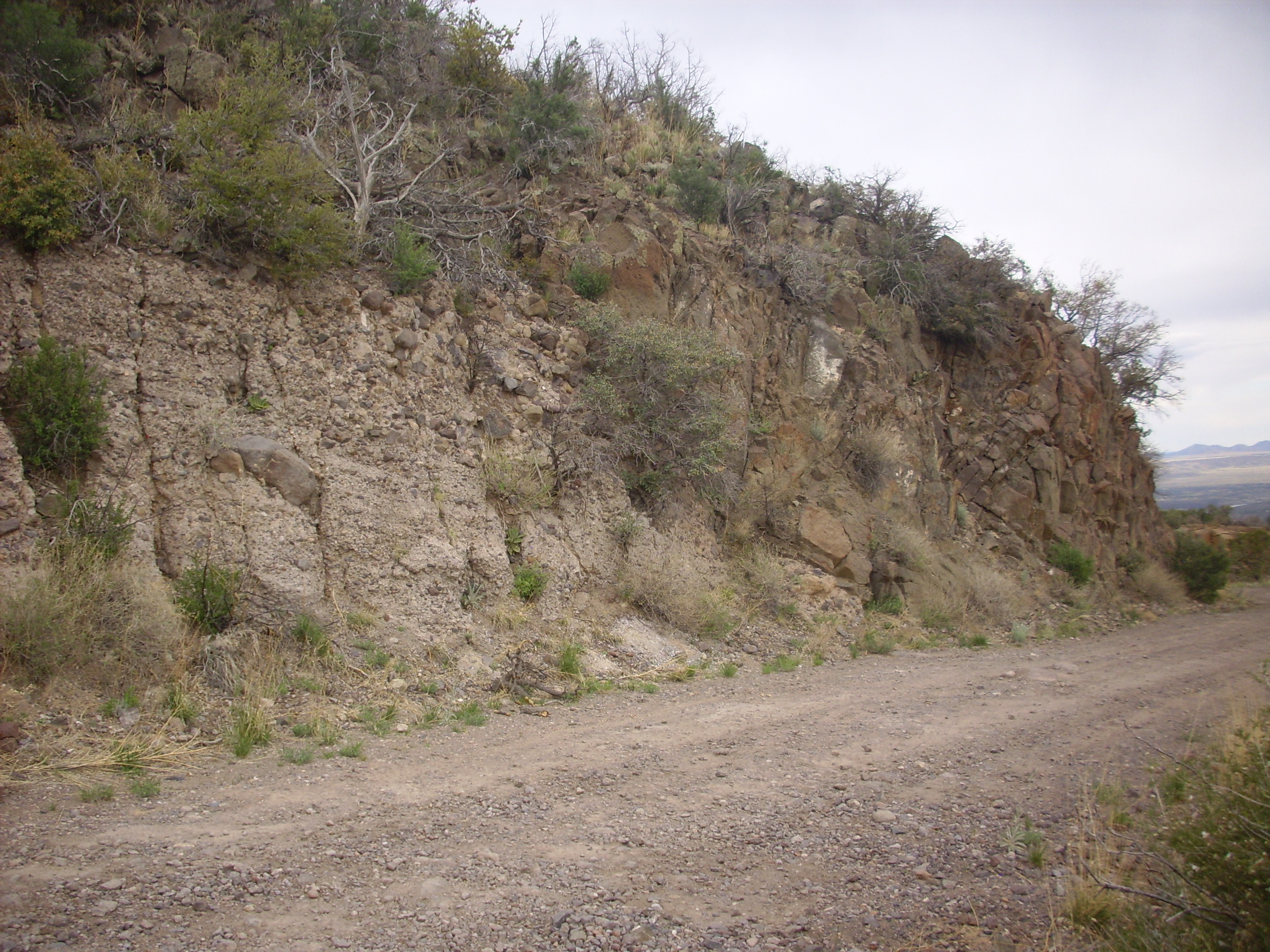
On the way out, I took a photograph of Cochiti Formation in the road cut.
Cochiti Formation in road cut near the Veteran’s Memorial Scenic Overlook. 35 39.985N 106 26.729W
At least, I think this is Cochiti Formation; the map is just a touch unclear here and this might be the overlying Lookout Park Gravel. But I don’t think so. The Cochiti Formation is similar to the Puye Formation in Pueblo Canyon, but older; it also has more red sand and clay in the ground mass and less gray volcanic ash. The boulders are eroded from the Keres Group, which includes the Paliza Canyon Formation and the Bearhead Rhyolite. You can see that there is a mixture of dark Paliza Canyon andesite and lighter Bearhead Rhyolite.
At this point I started improvising my trip furiously. I was obviously not going to head back out and around into the Jemez along State Road 4; way too late in the day. Nor was the thought of backtracking to I-25 and heading back to White Rock the usual way through Santa Fe all that appealing. I decided to go see how the Dome Road below the old Dixon apple orchard was doing; the last time I was there, it was an absolute mess, nothing to take a passenger vehicle through, but perhaps there had been some repair.
Heading north along the Cochiti Highway, one gets a marvelous view of the San Miguel Mountains from the south.
San Miguel Mountains viewed from near the town of Cochiti. 35 39.228N 106 20.154W
The peak to the left is Cerro Balitas, while the prominent peak at center is Cerro Picacho. Both are underlain by the Bearhead Rhyolite. The flat peak to the right is St. Peter’s Dome, while the the knob near the right edge of the photograph is Boundary Peak. Both St. Peter’s Dome and Boundary Peak are underlain by andesite of the Paliza Canyon Formation.
Bearhead Peak is also prominent from this location.
Bearhead Peak viewed from near the town of Cochiti. 35 39.228N 106 20.154W
This picture turned out a bit fuzzy, so I haven’t bothered linking the full resolution version.
The foreground mesas in both photographs are Bandelier Tuff.
When I got to the spot in the road below the Dixon orchard, I found it a mess. I stopped, got out of my car, and scouted ahead on foot to see if I could cross. The roadbed, though soaked and ponded, looked fairly firm; there was a nasty patch of rock garden beyond that, but from then on it looked okay. There were also three pickup trucks parked just past the bad spot, with their drivers out having a conversation, and I figured, hey, if I really get stuck …
I made it. I bottomed out slightly in the very worst part of the rock garden, to the visible amusement of the pickup truck drivers, but no real damage done. They were, however, visibly surprised when I told them I intended to drive clear through to Los Alamos. “Good luck…”
Okay, I was probably being just a bit reckless.
The road climbs out of Eagle Canyon (that’s the name my map gives to the canyon the Dixon orchard is in) and climbs around the north side of a mesa south of a small canyon that is unnamed on my maps. The Bandelier Tuff is fairly impressive here.
Bandelier Tuff in unnamed small canyon just north of Eagle Canyon. 35 41.972N 106 22.175W
As is typical of the Bandelier Tuff, the Tsherige Member forms cliffs and the Otowi Member forms gentler slopes beneath, with occasional tent rocks. The contact here is hidden by colluvium (that is, in geology jargon, “dirt”).
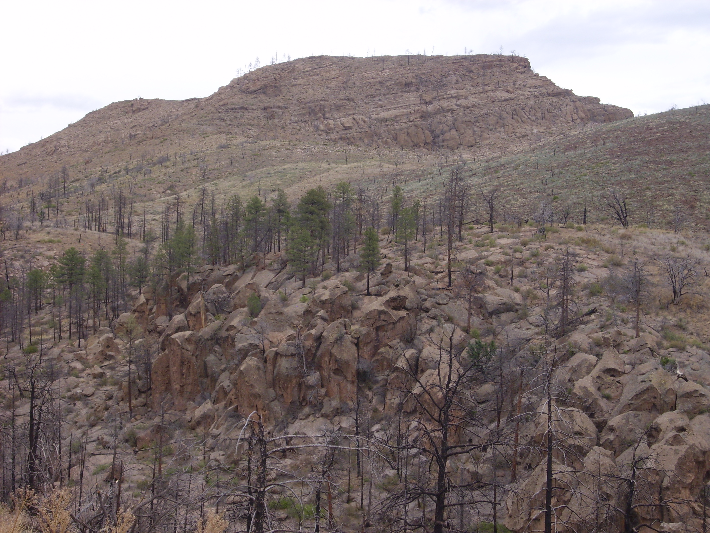
The road climbs atop the mesa and affords a nice overlook to the south.
Eagle Canyon from north rim overlook. 35 42.491N 106 23.080W
The canyon floor was occupied by the Dixon apple orchard until the devastating 2011 Las Conchas fire, which burned part of the orchard. The watershed for the canyon was heavily burned, and subsequent flash floods destroyed what was left of the orchard. Nary an apple tree is visible from this overlook point.
In the first frame, the Ortiz Mountains are visible to the southeast. These are among oldest examples of volcanism on the Rio Grande Rift, with an age of around 30-25 million years. Sandia Crest is visible at the center of the second frame, representing much younger fault mountain building on the east side of the Rift. The canyon walls are Bandelier Tuff, with a thin layer of Otowi Member at the bottom and Tsherige Member forming the rest of the canyon walls.
The final frame is particularly significant. (Click for a full resolution version.) The escarpment crossing the boundary of the third and fourth frame marks the trace of the Pajarito Fault, which continues north across the east face of the San Miguel Mountains and the Sierra de los Valles just west of Los Alamos. The fault trace is well exposed in the canyon wall — in fact, this is the most dramatic exposure of the Pajarito Fault I’ve seen. To the left (east) is Bandelier Tuff, while to the west is an exposure of dark andesite of the Paliza Canyon Formation. Note that the Bandelier Tuff is significantly thicker on the left side of the fault; there was already an escarpment and the pyroclastic flow that produced the tuff ponded on the east side along the escarpment. This shows that the fault was already active before 1.6 million years ago, when the Otowi Member of the Bandelier Tuff was emplaced. The displacement in the Bandelier Tuff shows that the fault has been active within the last 1.2 million years, since the emplacement of the Tscherige Member of the Bandelier Tuff. In fact, geologists believe the Pajarito Fault is a very old fracture in the earth’s crust, perhaps older than 50 million years. During the Laramide Orogeny of the early Tertiary, 50-30 million years ago, it was the east side of the fault that was thrown up, due to tectonic compression, forming the Pajarito Uplift in the area between what is now Santa Fe and Los Alamos. The area now occupied by the Jemez was a river valley in which the El Rito Formation and Gallegos Formation were deposited. With the end of the Laramide Orogeny 30 million years ago, compression was replaced by extension and the Pajarito Fault reversed, so that the Pajarito Uplift became part of the Espanola Basin of the Rio Grande Rift.
The road continues west and actually climbs north up the face of the Pajarito Escarpment, giving a nice view of the mesas below.

Looking east from the Pajarito Escarpment. 35 42.717N 106 23.176W
This is a wonderful view out across the Cerros del Rio, the basalt plateau southeast of White Rock. This was erupted around 3 million years ago.
The first frame looks north along the Pajarito Escarpment. The small knob on the near skyline is an unnamed hill southeast of the San Miguel Mountains, which is underlain by Gallisteo Formation. The Gallisteo Formation was deposited west and south of the Pajarito Uplift 50-30 million years ago and consists mostly of red sandstone, interbedded with some red mudstone. The exposure here, where the formation has been brought to the surface by faulting, is the furthest northern exposure of the formation, which is more prominent southeast of Santa Fe and can be examined close up at the Cochiti exit from I-25. (Where it is also exposed by faulting.)
The near skyline on the second and third frames is the Cerros del Rio. The hill furthest north, near the center of the second frame, is probably Montoso Peak. The hilly terrain to its right includes Cerro Micho and Twin Hills. The peak to the left in the third frame is Colorado Peak, while the peak to the right in the third frame is Tetilla Peak. To its right in the fourth frame is Cochiti Reservoir and the Ortiz Mountains, and Sandia Crest is prominent in the final frame.
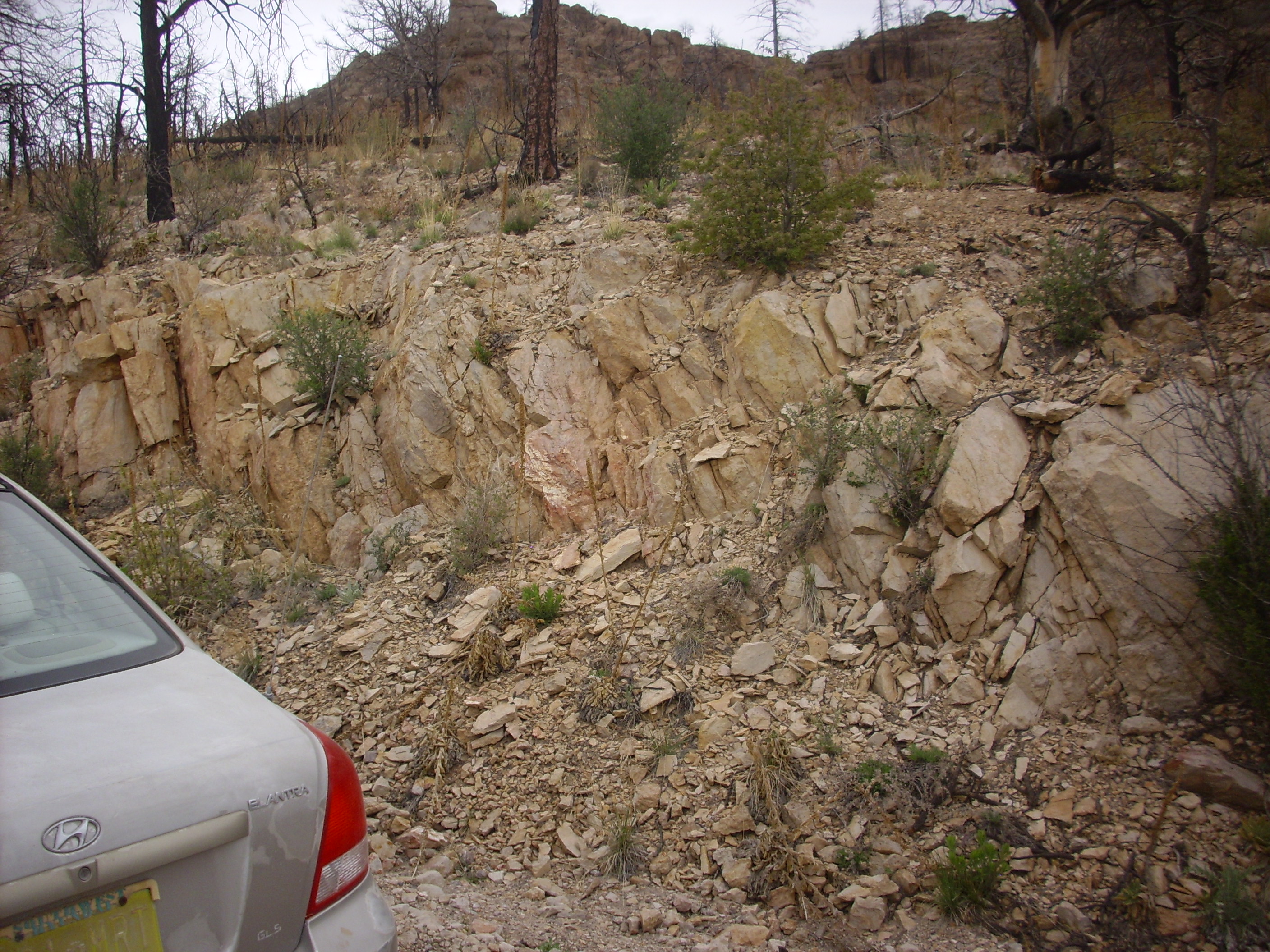
As the road crosses the crest, we see some contacts in the road cut.
Contact in road cut. 35 42.800N 106 23.406W
The hill behind this road cut is the location of a source vent for the Paliza Canyon Formation. To the right in the road cut is solid porphyritic andesite; to the left is volcaniclastics, which was possibly deposited by a lahar (a volcanic mudflow.)
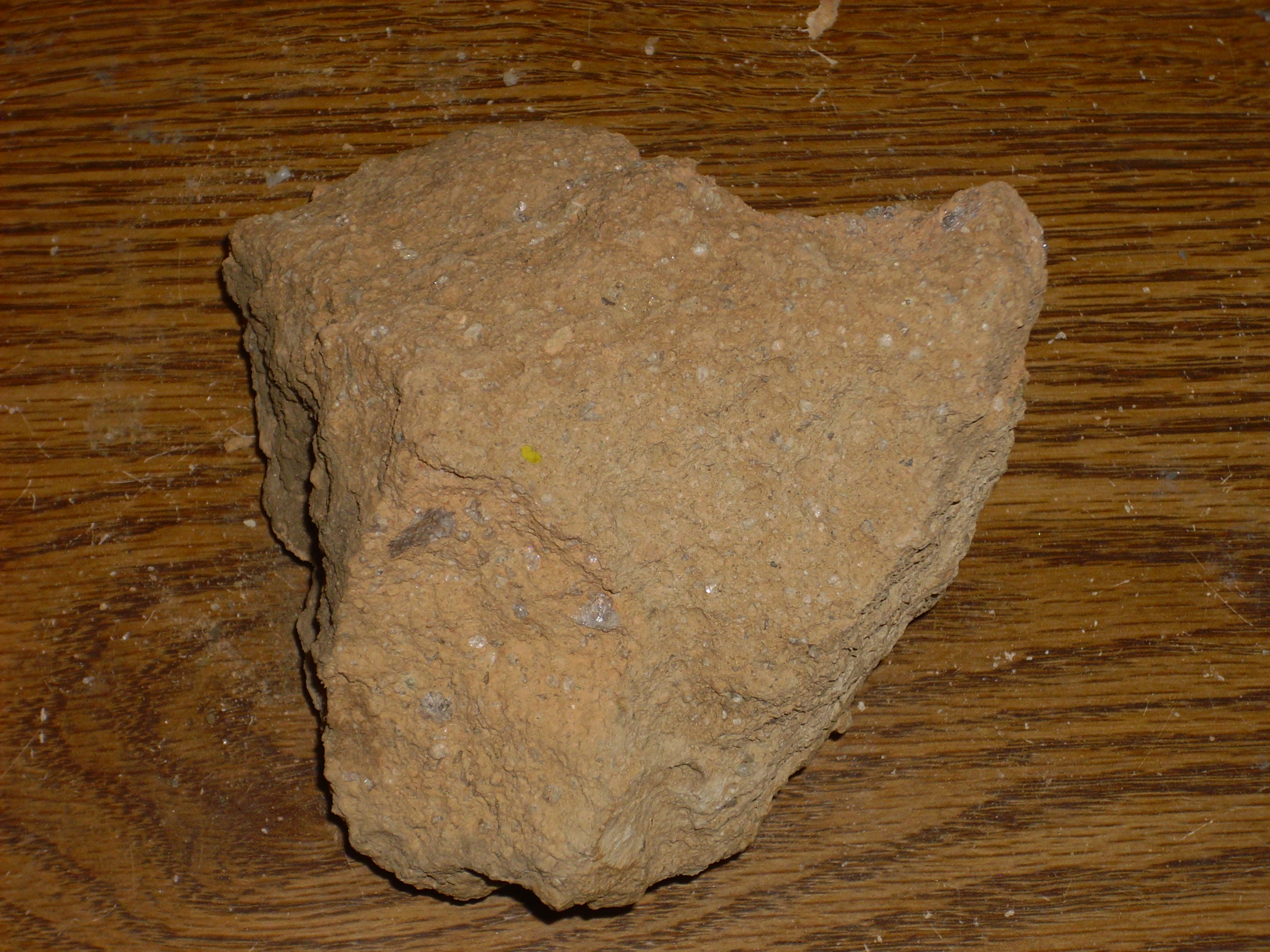
Here’s a sample of the andesite.

Porphyritic andesite. 35 42.800N 106 23.406W
The andesite in this location shows signs of having been hydrothermally altered. Under the loupe, one sees yellow discoloration, oxidized patches of what were mafic minerals (including some well-preserved pseudomorphs, where the shape of the original crystal is well-preserved even though it has rusted red) and small cavities with quartz linings, like tiny geodes.
Just a few yards further up the road, there is another contact, between the volcaniclastics and the Tsherige Member, Bandelier Tuff:

Contact in road cut. Just north of 35 42.800N 106 23.406W
There are surge beds in the Tsherige Member along the contact, and also near ground level to the left. The Tscherige Member is here a particularly vivid red, which may also be an indication of hydrothermal alteration.
Tsherige Member. Just north of 35 42.800N 106 23.406W
There are numerous bore holes here and in an outcrop on the other side of the road, suggesting this rock has attracted attention from geologists. I don’t have any dates marked on my map for this area, though a nearby andesite outcrop is dated to 9.33 million years.
And next to the bore holes are some hash marks scratched crudely in the rock. Either this is some kind of Secret Geologist Language, or some non-geologist is less than overawed by the activities of scientists.
The road heads north from here, affording a very nice view of Cerro Balitas.
Cerro Balitas viewed from 35 43.311N 106 24.162W
The foreground is Tsherige Member, the darker ridge behind it is Paliza Canyon Formation (a northward extension from the vent near the roadcut earlier) and Cerro Balitas is Bearhead Rhyolite with a cap of Peralta Tuff. The road cuts through a plug of Bearhead Rhyolite as it passes west of Cerro Balitas.
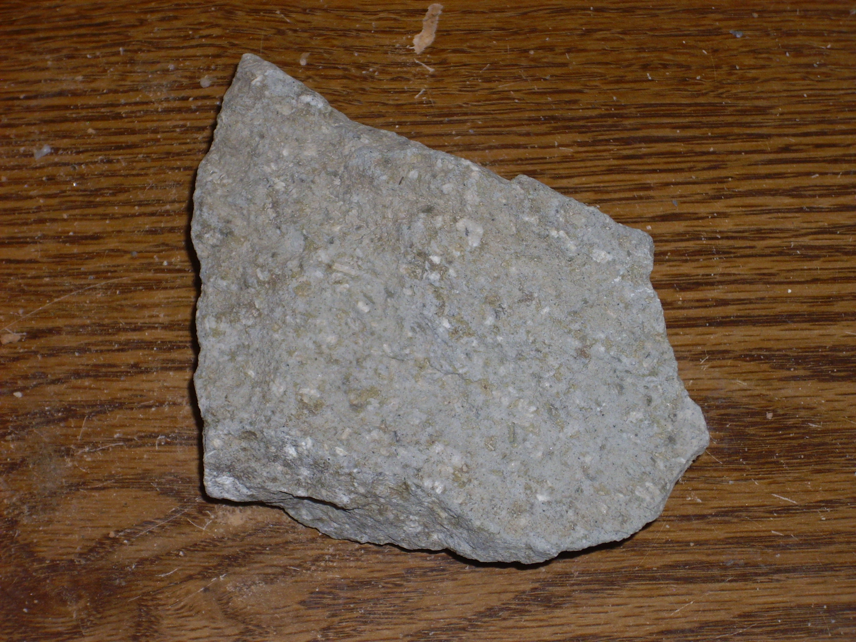
Outcrop of Bearhead Rhyolite. 35 44.049N 106 24.555W
My geological map maps this as hypabyssal rhyolite, which cooled some distance underground. Here’s a sample.

Bearhead Rhyolite. 35 44.049N 106 24.555W
There are signs of flow banding. Under the loupe, the sample shows sparse phenocrysts of feldspar, quartz, and biotite mica. The ground mass is very fine grained, almost like a siltstone.
A final shot of the San Miguel Mountains.
San Miguel Mountains. From 35 44.347N 106 24.499W
To the right is Cerro Picacho. To its left is St. Peter’s Dome. At extreme left is Cougar Hill, a plug of Paliza Canyon andesite and Bearhead Rhyolite.
Finally, I stopped at a point on the road where andesite was mixed with El Cajete Pumice.
Andesite and pumice. 35 46.373N 106 25.290W
The andesite here is strikingly porphyritic.
Andesite and pumice. 35 46.373N 106 25.290W
Under the loupe, numerous small crystals of black hornblende are visible.
It was getting late. From here I drove on to State Road 4 and home.
Copyright ©2015 Kent G. Budge. All rights reserved.