
Wanderlusting Kashe Katuwe
I had business in Albuquerque Friday morning, and discovered at lunch time that my newest favorite restaurant, the Saffron Tiger on Paseo del Norte, has permanently closed. Crep. I found myself settling for a kosher hot dog from Five Guys next door. Yeah, I could probably have done a lot better; I just didn’t want to fight through traffic to do it.
And it’s not like the hot dog wasn’t tasty. It’s just not the healthiest diabetic food.
I looked over my trail guide while eating, but nothing really resonated. Perhaps a hike in the Sandia foothills; meh. Perhaps Arroyo del Tuerto; there’s a fossil quarry and a petrified forest there, which sounded really interesting, but it would mean picking up a key from the BLM office in Albuquerque, and then risking a punctured tire when I got to the trail head, which is apparently notorious for its road hazards. Also, there was a lot of rain earlier this week, so it seemed prudent to avoid dirt roads. I decided a short trip to hike the slot canyon at Kashe-Katuwe Tent Rocks sounded as good as anything. I’ve been before but it was a long time ago.
North of Albuquerque, I paused along the interstate for a road cut I’ve been wanting to photograph for a long time.
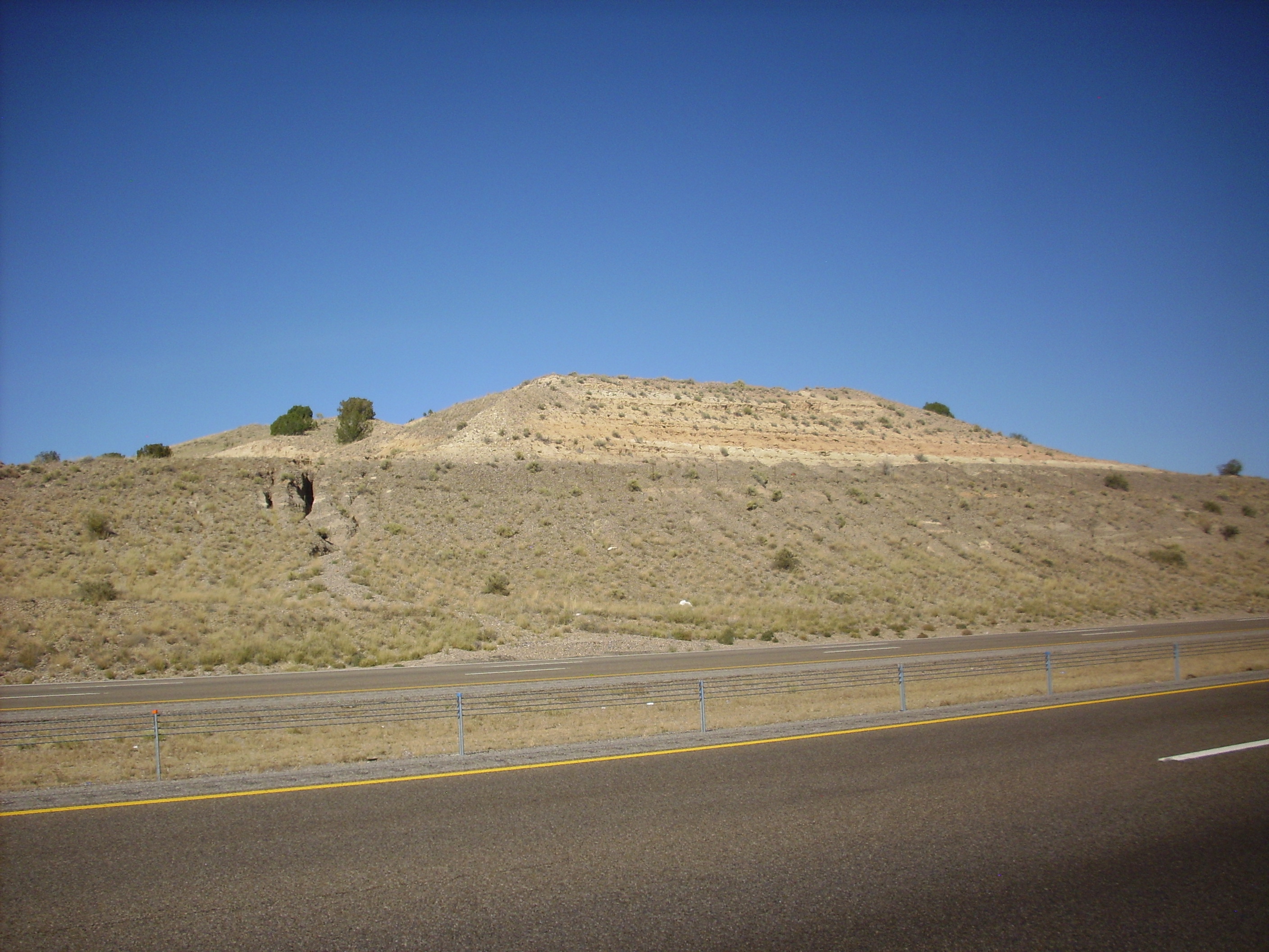
The gray beds making up the lower part of the road cut are a coarse gravel, while the lighter beds at top look like sandstone or siltstone. The contrast is quite striking. This entire area is mapped as Santa Fe Group, which includes all the rift fill sediments of the Rio Grande Rift, the great crack in the Earth’s crust reaching from central Colorado to El Paso that largely coincides with the Rio Grande Valley. The Rift began opening about 30 million years ago, as the Colorado Plateau began to pull away from the rest of North America, and the Rift began to fill with sediments eroded off nearby higher ground almost as fast as it opened. (That’s why we don’t actually see an enormous canyon splitting New Mexico in half.)
The beds here are described as axial conglomerates and sandstones of the ancestral Rio Grande. (The modern river runs a couple of miles to the west.) These sediments were deposited by the Rio Grande within the last three million years or so. The geologic map for this area notes that similar sediments further south are assigned to the Sierra Ladrones Formation. If you look up the map for the area to the north, you find it has also assigned similar sediments to the Sierra Ladrones Formation. So it seems like we might as well call this Sierra Ladrones Formation as well.
The contact is not called out on the map. I find that slightly disappointing; it seems like such a dramatic contact. There are beds a short distance to the west mapped as eastern piedmont conglomerates and sandstone, but their description doesn’t really fit the light beds at top any better than the axial conglomerates and sandstones.
I take the Cochiti exit but turn south briefly rather than immediately heading north. I want to get a good photograph of a fault trace here.

I am standing just east of a major fault, the Bajada Fault, which splits off the Pajarito Fault near the San Miguel Mountains to the north and runs south past my location to join the Tijeras Fault Zone east of the Sandia Mountains. This fault throws down the beds to its west to form the La Bajada escarpment, which, along much of its length, defines the eastern boundary of the Rio Grande Rift at this latitude.
Just south of where I’m standing, the fault branches, and a smaller eastern strand of the fault turns northwest and runs along the base of the cliffs to the right. The yellowish tan beds forming the edge of the cliff are the Salt Wash Member of the Morrison Formation, composed mostly of sandstone laid down by a river system during the Jurassic Period, some 156 million years ago. These cliffs end on the skyline just left of center; the gray cliffs peeking over the Salt Wash Member at the center of the panorama are much young basalt of the Cerros del Rio, with an age close to three million years.
The red beds north (left in the photo) of the fault belong to the Galisteo Formation, an Eocene formation laid down by another river system between 42 and 38 million years ago. Their presence next to the much older Salt Wash Member shows that the beds to the left have been thrown down a considerable distance by the fault. Also, if you look closely to the beds at the left, you will see that they are tilted upwards. The beds have been deformed by the motion along the fault (fault drag) but become more or less level further north. The motion along the fault is not strictly up and down, however; the geologists who mapped it concluded that there was some horizontal motion along the fault, such that the beds to the left are shifted towards me relative to the beds to the right — an example of left lateral slip, because whichever side of the fault you are standing on, you will see the beds on the other side of the fault displaced to the left.
After the fault passes over the skyline, just left of center in the photograph (where the red soil gives way to tan soil), it begins to curve around more towards the north, but continues separating young Eocene and Oligocene beds from older Jurassic beds. The fault then passes under the lava flows of the Cerros del Rio and becomes untraceable a few miles further north. These flows unhappily (for geologists) conceal much of an accomodation zone where the eastern boundary of the Rio Grande Rift takes a jog to the east.
I continue on to Cochiti, admiring geology I’ve seen (and photographed) many times before. But as I’m approaching Cochiti Dam, the little yellow light on my dashboard comes on. Crep, I forgot to fill up my tank before leaving Albuquerque. I make it to the gas station in Cochiti Town and refuel. Then back through the pueblo and north to the monument entrance. Here there is some further awkwardness: My annual interagency parks pass expired August 31, I would like to renew it, but they aren’t set up to take credit cards and I don’t carry checks or that kind of cash ($80). I decide paying $5 for the day is not a big deal, and drive on to the parking area.
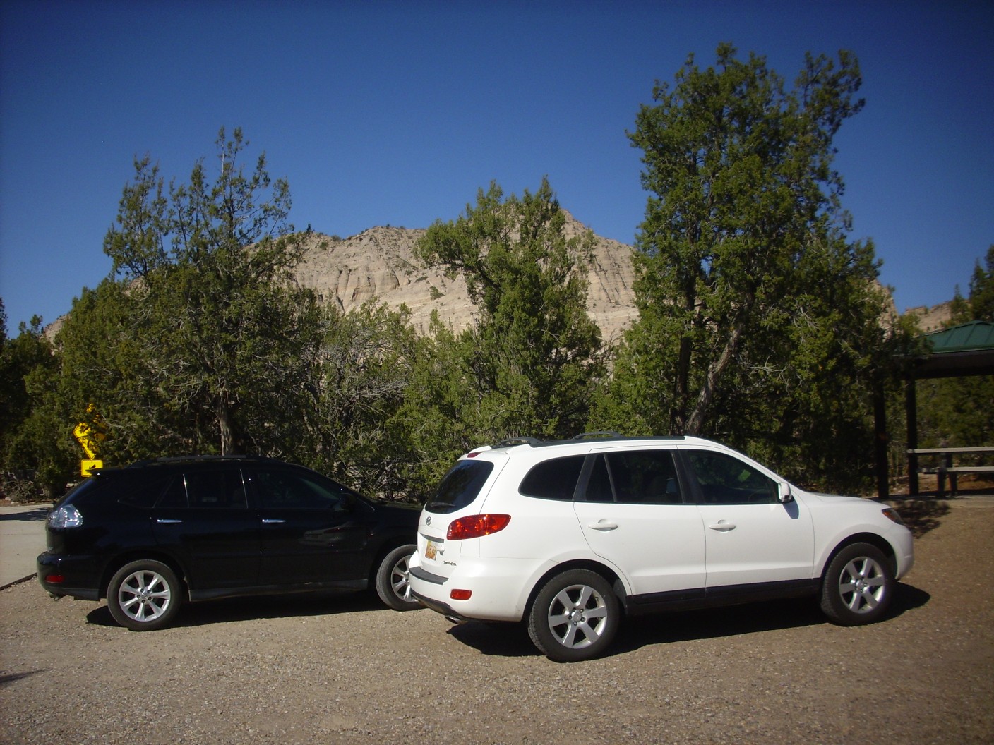
The white car is the Wandermobile. I find a line at the restroom but am soon on the trail.
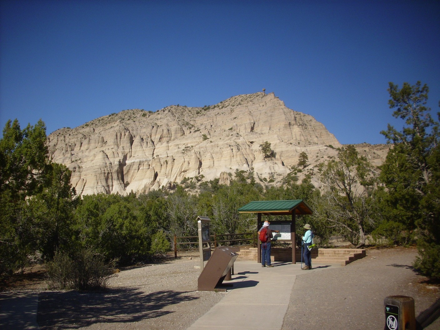
The hill in the background displays the thinly bedded ash and sediments of the Peralta Member, Bearhead Rhyolite. Let’s jump back a few million years for context. As the Rio Grande Rift opened, it thinned the crust directly under the rift, causing hot mantle rock to rise closer to the surface, which is an invitation for the rock to begin melting. The deep crust and upper mantle at the latitude of the Jemez Mountains seems to be particularly rich in hydrous (water-bearing) minerals, making them fertile for magma production.
The zone of hydrous rock extends far to the southwest and northeast, producing a chain of young volcanic features called the Jemez Lineament. This may coincide with a subduction zone dating clear back to the Paleoproterozoic, 1.7 billion years ago, where new crust first fused onto the southern edge of North America to form the basement of most of New Mexico. Basement is the term for crystalline igneous or metamorphic rock, devoid of fossils and often distorted beyond easy interpretation, that forms the deeper parts of the crust and on which relatively young sedimentary beds are deposited.
All that was needed was a route for the magma to reach the surface. This was provided by the faults forming the western boundary of the Rio Grande Rift, and around 14 million years ago this magma began to erupt at the surface. The early volcanic rock is assigned mostly to either the Paliza Canyon Formation or the Canovas Canyon Formation; the former is only moderately rich in silica while the latter is mostly a very silica-rich rock called rhyolite. The earliest beds were Paliza Canyon Formation, but Canovas Canyon Formation followed soon after, only to be buried by more Paliza Canyon Formation, which reached its peak eruptive activity between 10 and 8 million years ago. The Paliza Canyon Formation is probably the most voluminous formation of the Jemez Mountains.
The distinction between Paliza Canyon Formation and Canovas Canyon Formation is more than an arbitrary cutoff in silica content. Trace elements and isotope ratios suggest that Paliza Canyon Formation originated in the upper mantle, with limited contribution from melted crust, while Canovas Canyon Formation is mostly melted crust.
About 7 million years ago, there was an extensive eruption of fresh rhyolite, which (because it generally intrudes through or sits on top of Paliza Canyon Formation) is assigned to a distinct formation, the Bearhead Rhyolite. The first eruptions were mostly tuff rather than massive rock. Tuff is volcanic ash, either cemented together by its own heat as it settles to the surface (primary tuff or ignimbrite) or carried by water to low areas and cemented together by silica (reworked tuff). The tuff beds are assigned to the Peralta Tuff Member of the Bearhead Rhyolite by geologists.
The beds you’re seeing in the hillside in the previous photograph are a mixture of primary and reworked tuff, along with occasional beds containing eroded soil or other sediments. As a rule of thumb, the more pure white a layer, the more likely it is to be a primary tuff or a reworked tuff with limited soil content.
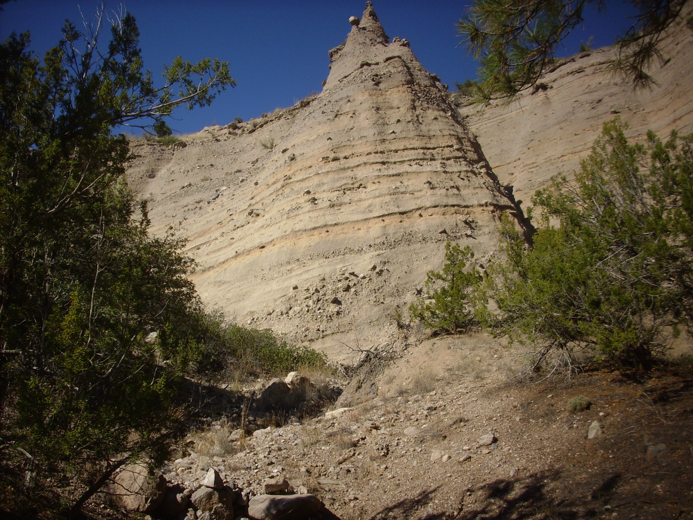
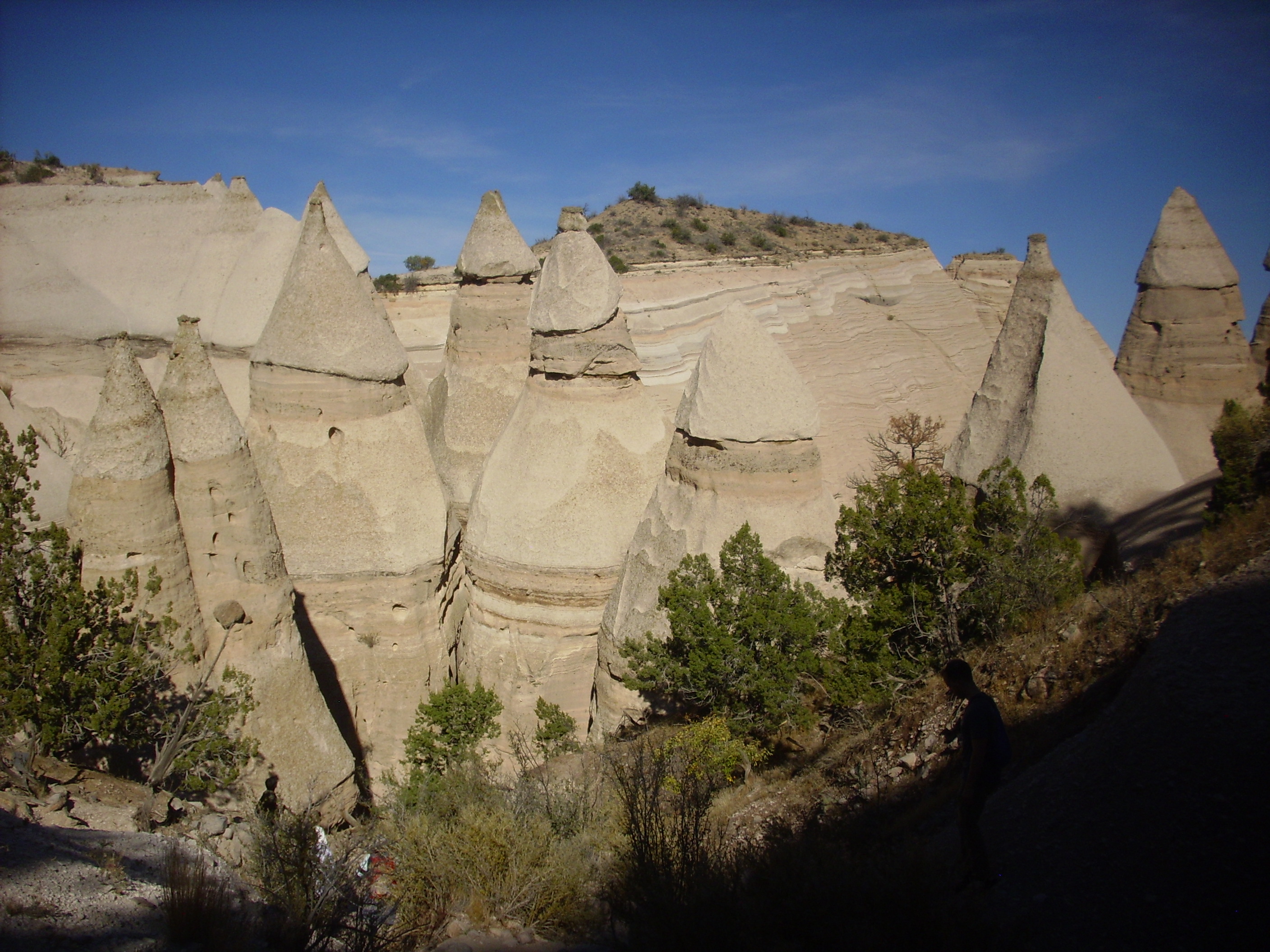
Here is a tent rock along the trail.
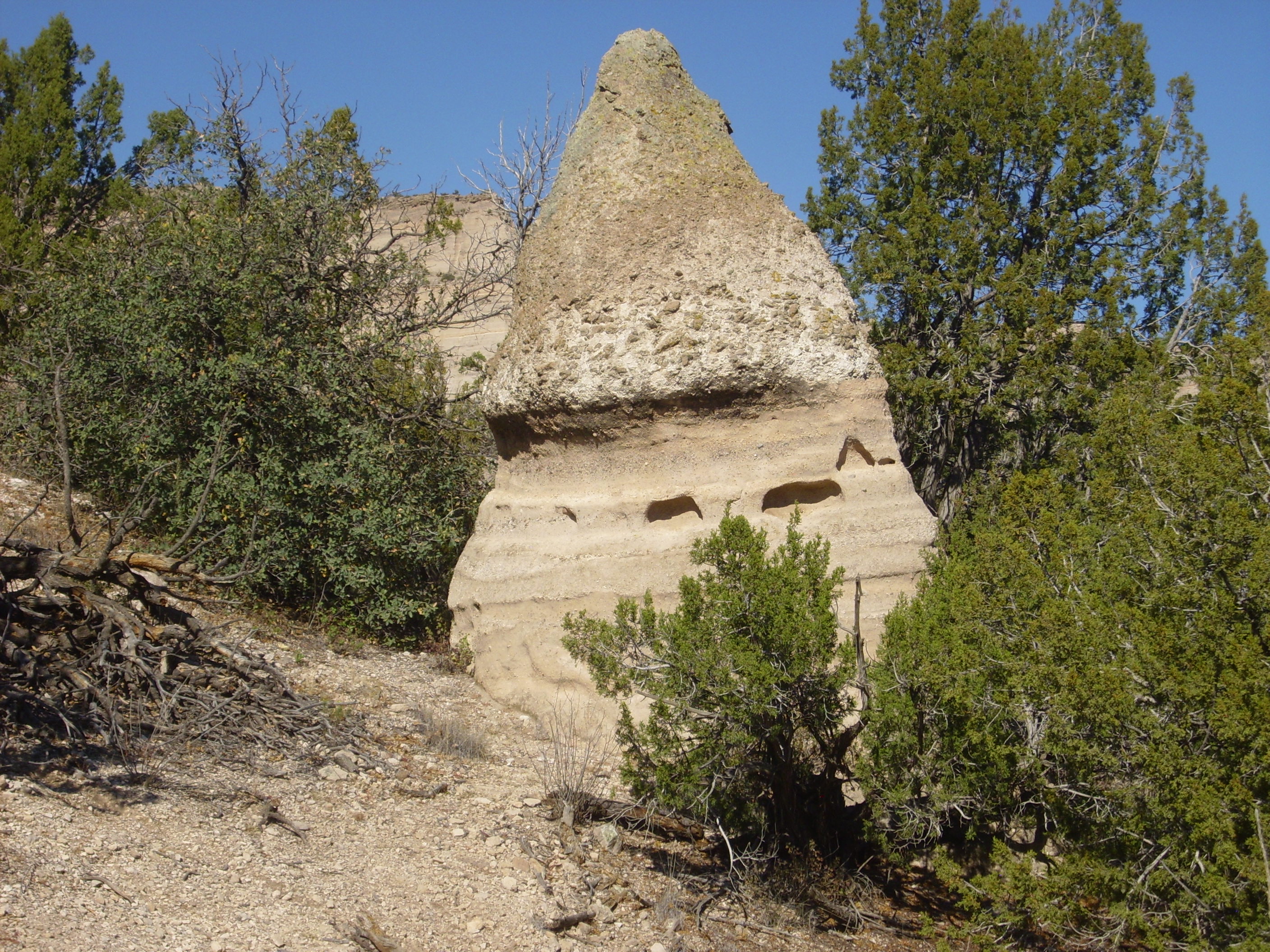
There may once have been a boulder capping the rock, protecting the softer material beneath from erosion; if so, it’s long gone. It’s also possible no boulder was required to form this feature, which formed naturally from erosion of a harder bed on top over a softer bed beneath. The lower bed looks like an unwelded tuff (formed from ash that was already partly cooled when it settled to the surface) while the upper bed may be a welded tuff (still very hot when the ash settled) full of pumice fragments caught up in the ash flow.
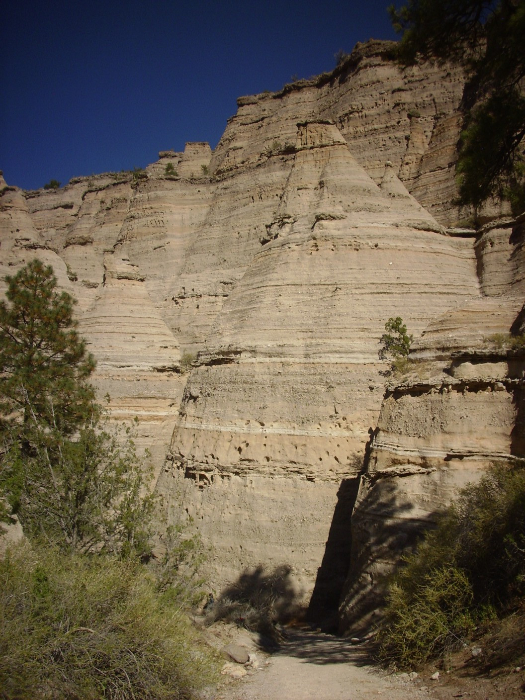
More beds ahead.
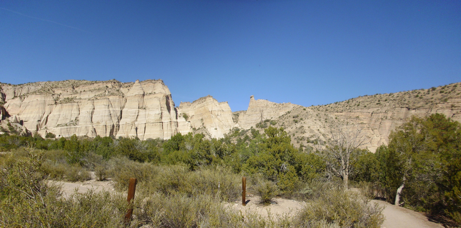
The Peralta Tuff is overlain by the next younger formation in this area, the Cochiti Formation, which is coarse to fine sediments eroded off the mountains to the north and west. It forms the gray rim of the hills, particularly evident to the right.
A closer look at the Peralta Tuff.
I haven’t sufficient training or experience to be sure which beds are primary tuffs, reworked tuffs, or soil layers. But I think the rocky layer at bottom is probably a debris flow, formed from rocky material lubricated by mud that slid across the area.
Another close look.
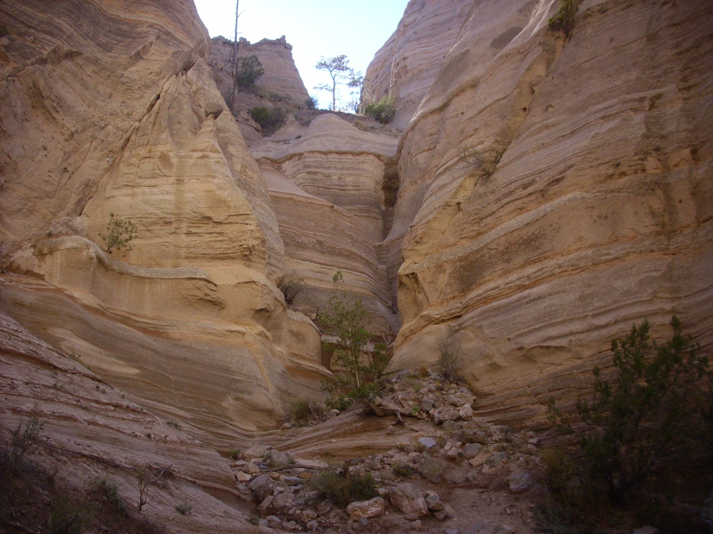
I am headed into a slot canyon, where water has carved a very deep notch in the tuff beds. At the mouth of the slot canyon is “Eleanor”, a Ponderosa pine whose roots have been exposed by recent erosion.
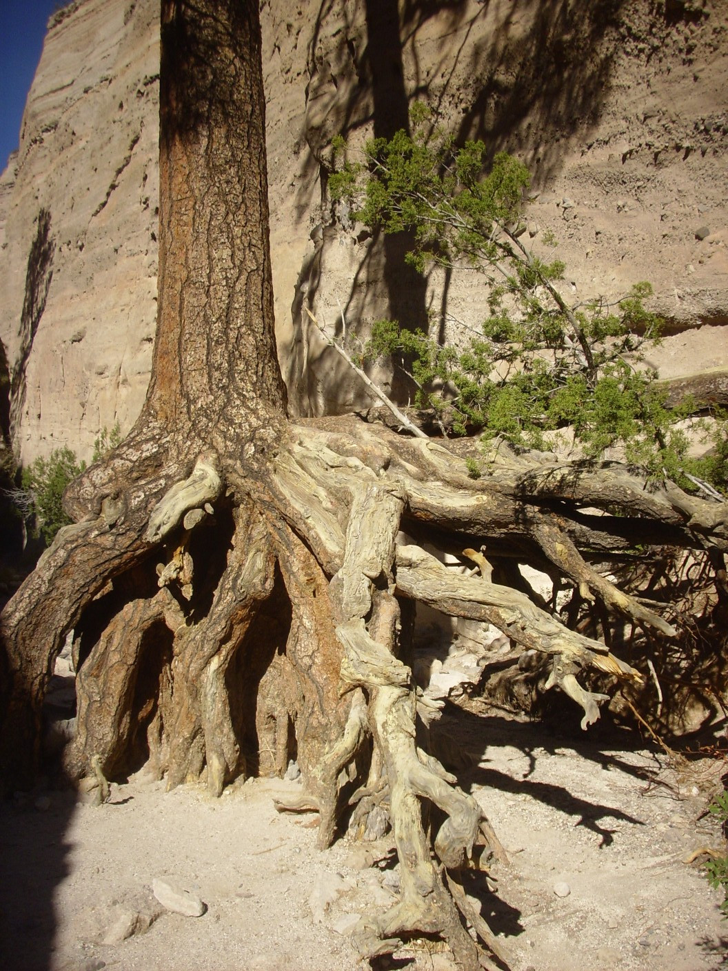
Ponderosa pines live to be about 600 years old. If we assume this is a mature tree, that means at least three feet of erosion in 600 years, which is a phenomenally high erosion rate in geologic terms. The erosion is likely episodic; a ranger I spoke to mentioned that a flash flood last October noticeably lowered the soil level around Eleanor.
Recent rainfall seems to bring out the banding in the beds, by selectively soaking the more porous layers.
It took some time for me to get a good GPS lock on this position; the receiver does not function that well in the deep canyon. As I was waiting, I became aware of a loud buzzing sound from overhead. Sure enough, there was a crack in the canyon wall overhead with swarms of bees visible around it: A wild honeybee hive.
The canyon becomes very narrow in spots.
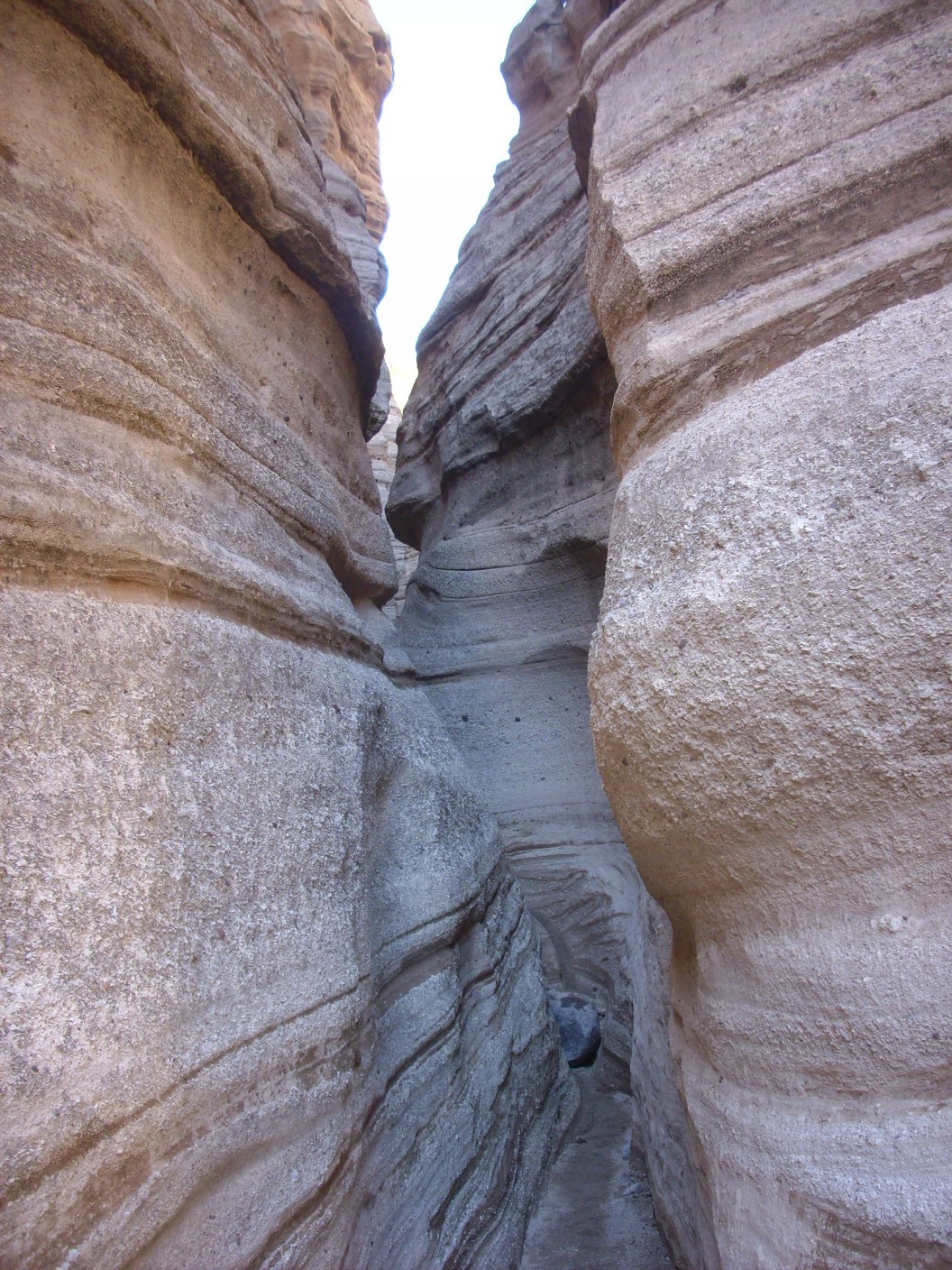
Unsurprisingly, it becomes almost impossible to get a reliable GPS lock in this section of the canyon.
But emerging from the deep slot, one comes to absolutely beautiful beds.
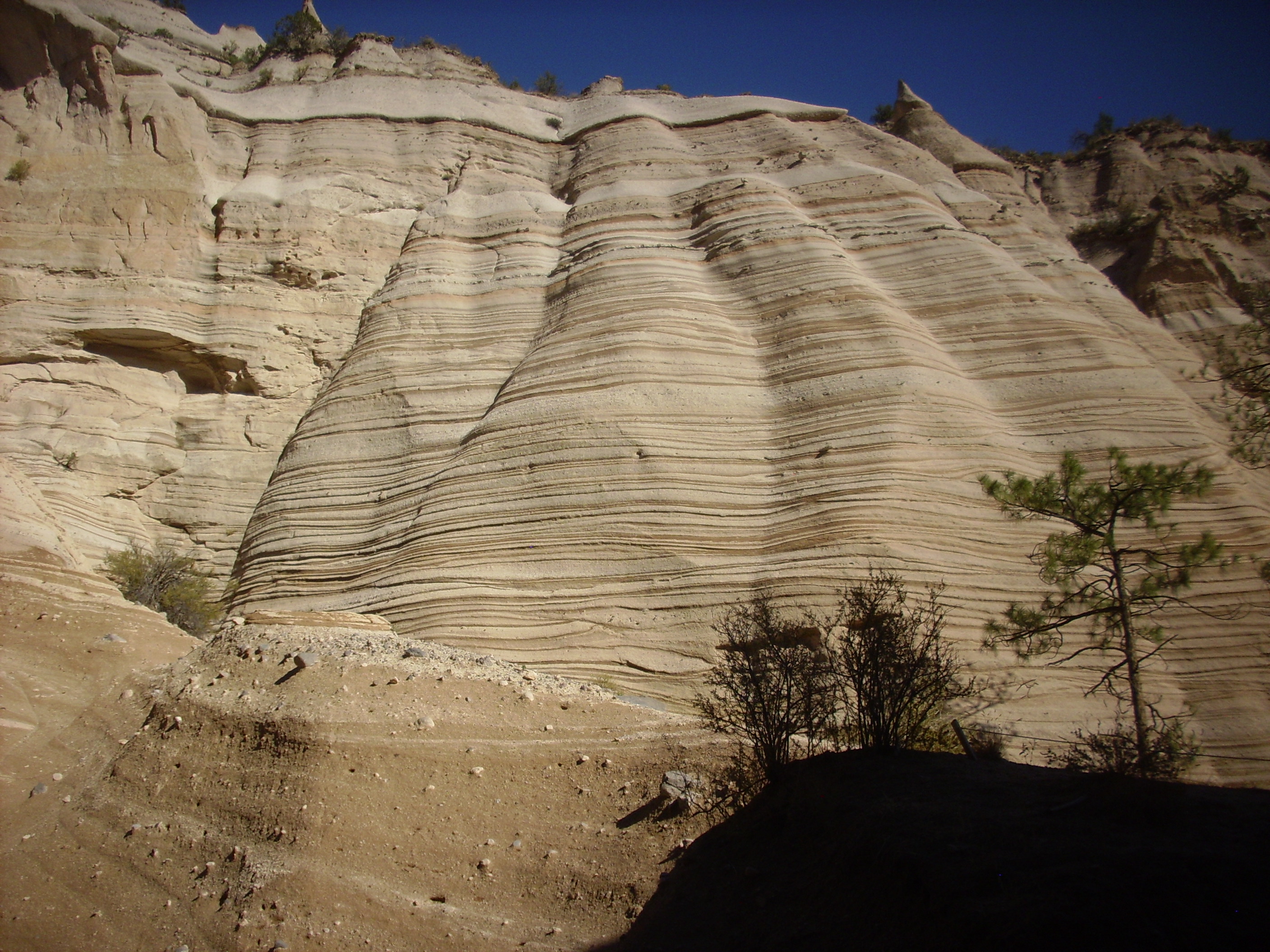
Again, the recent rain has accentuated the bedding.
A beautiful example of an angular unconformity:
Notice that the beds at the very top cut across the beds beneath along a flat surface. This is the angular unconformity, across which the beds lie at a different angle. This suggests that something — perhaps an earthquake along a nearby fault — tilted the lower beds, which were then eroded flat, and new beds were subsequently laid down at a slight angle.
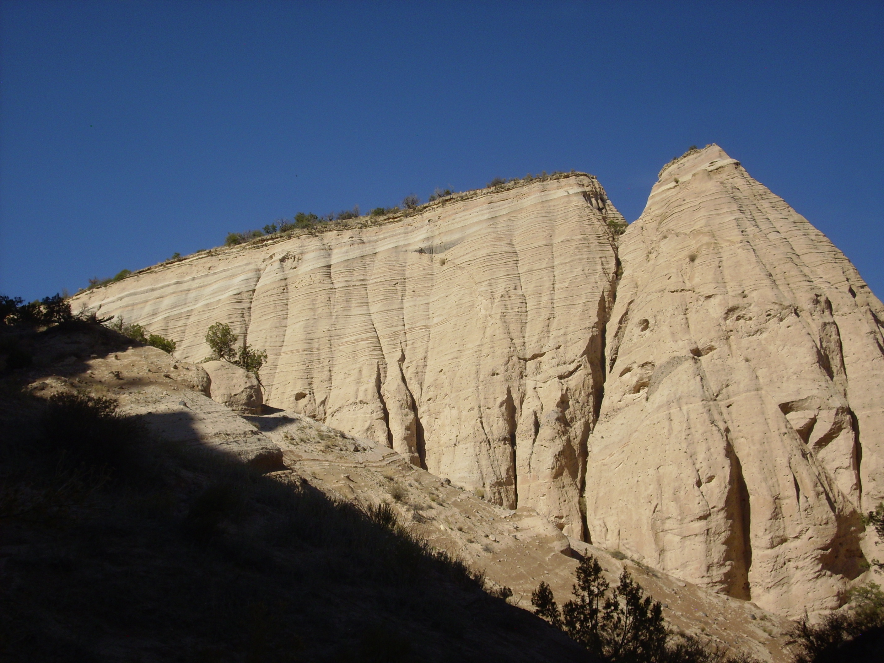
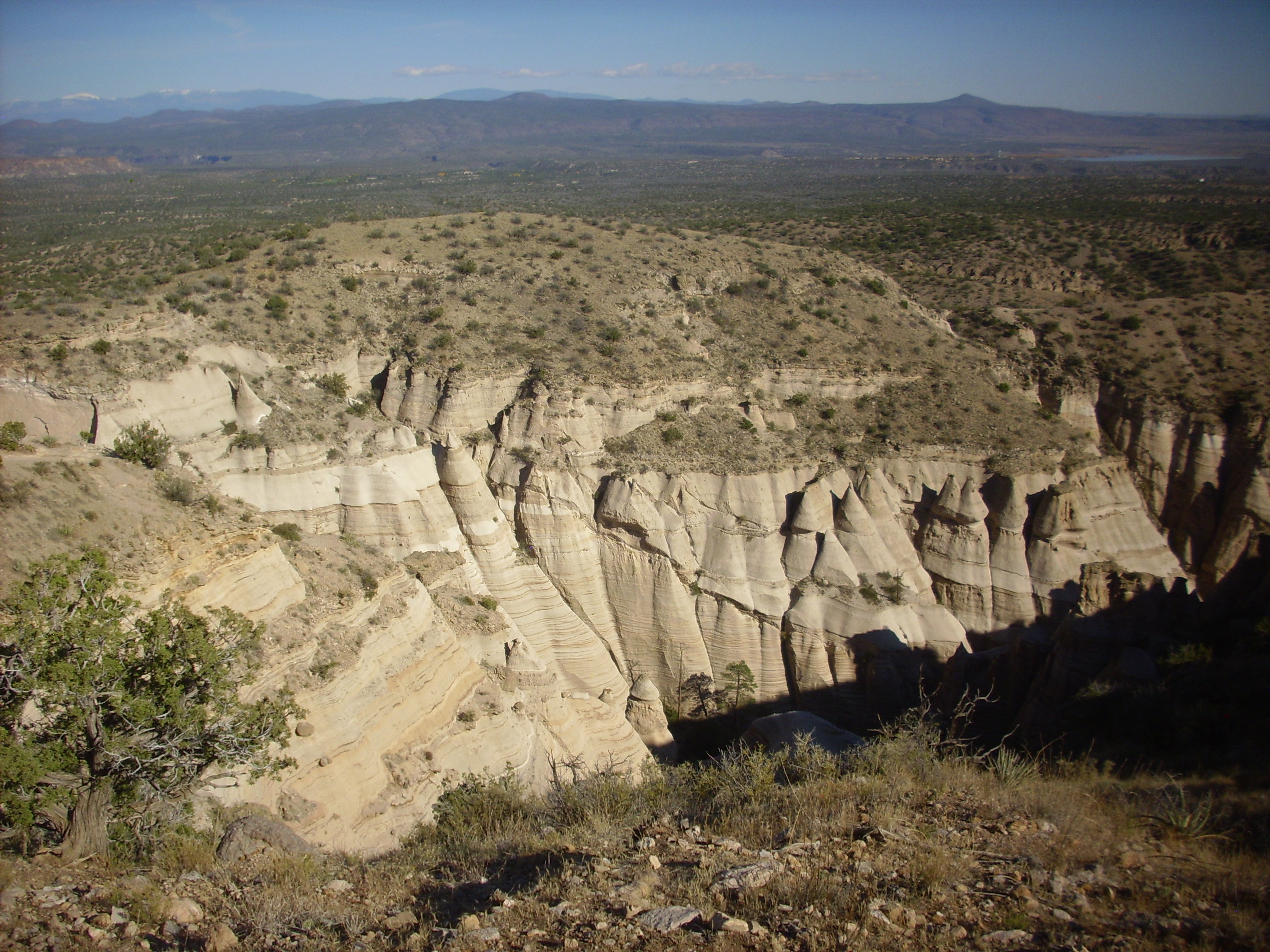
The trail ascends the steep face of the canyon wall, giving a nice view back into a nest of tent rocks.
Notice the thin rim of Cochiti Formation on the far canyon wall. The distinction from the underlying Peralta Tuff is clear. At this point, I am standing on more Cochiti Formation.
The trail is fairly busy today. It’s a beautiful day and a lot of people have a 9/80 schedule giving them alternate Fridays off. For once, I was probably above the median age; there were a lot of young couples on the trail.
You know, I really didn’t need the advice, but thanks:
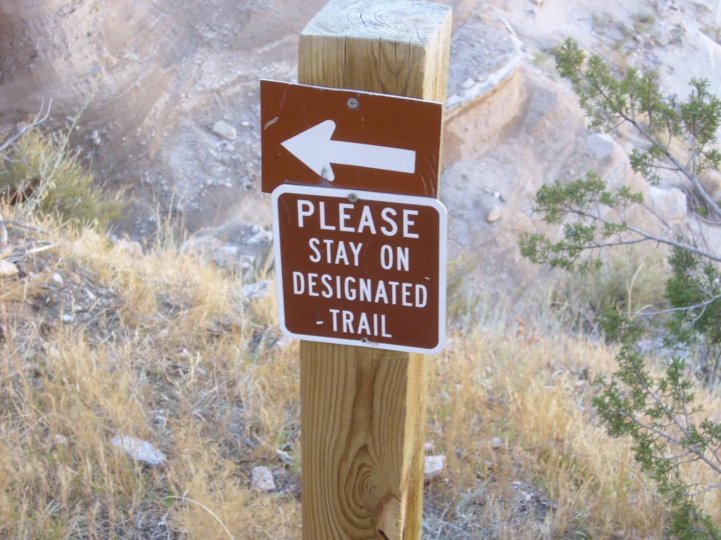
Because any way but on the trail would, at this point, mean a spectacular plunge to a quick death.
Heights don’t bother me overmuch, but I’m now old enough that testosterone no longer drives me to stupid stunts.
At the top.
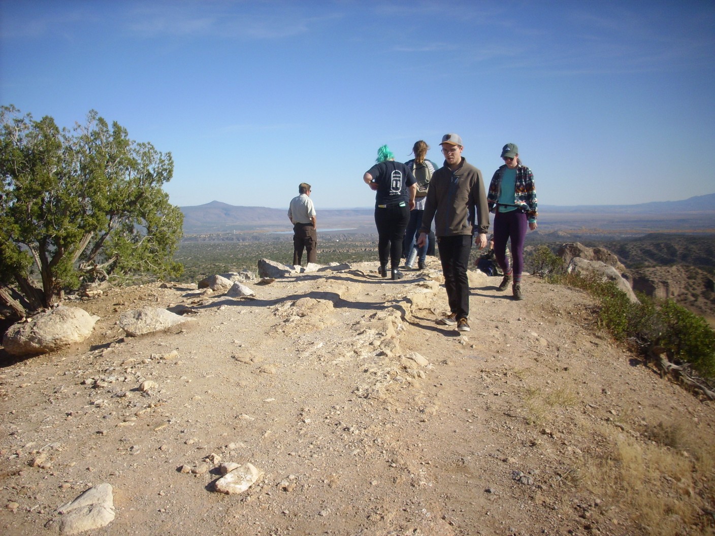
That’s Tetilla Peak left of the ranger in his green uniform. He was there to chivvy us off the trail when we got close to closing time, which in fact he did about five minutes later. I just had time to get a couple of nice panoramas.
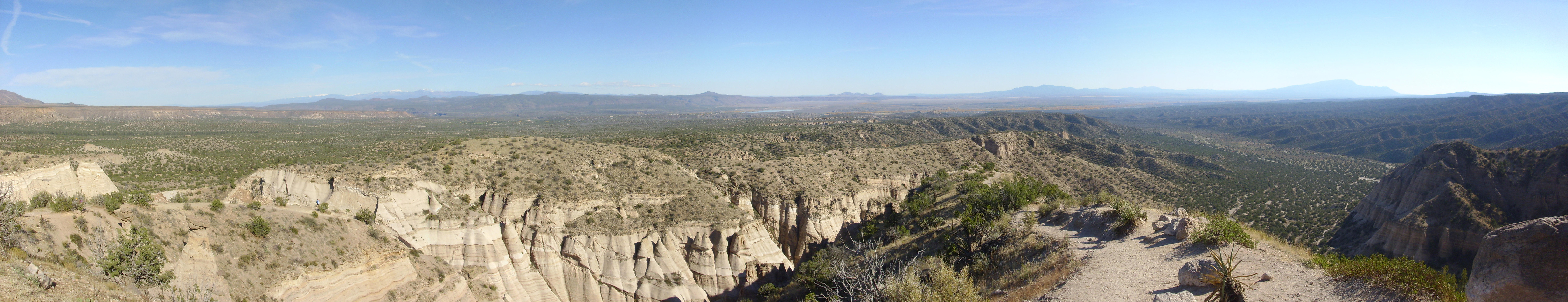
This is mostly towards the south. At farthest left is the San Miguel Mountains, and at center along the skyline is the Cerros del Rio Plateau, including Tetilla Peak. The comes the Ortiz Mountains and Sandia Crest. In the nearer distance at left is a long mesa of Bandelier Tuff, the ash laid down by the Valles eruption 1.25 million years ago that is probably the most celebrated geologic feature of the Jemez. The slot canyon fills the foreground, of course, and in the middle distance at far right is the badlands eroded out of the Cochiti Formation.
A panorama centered more to the north and northeast.
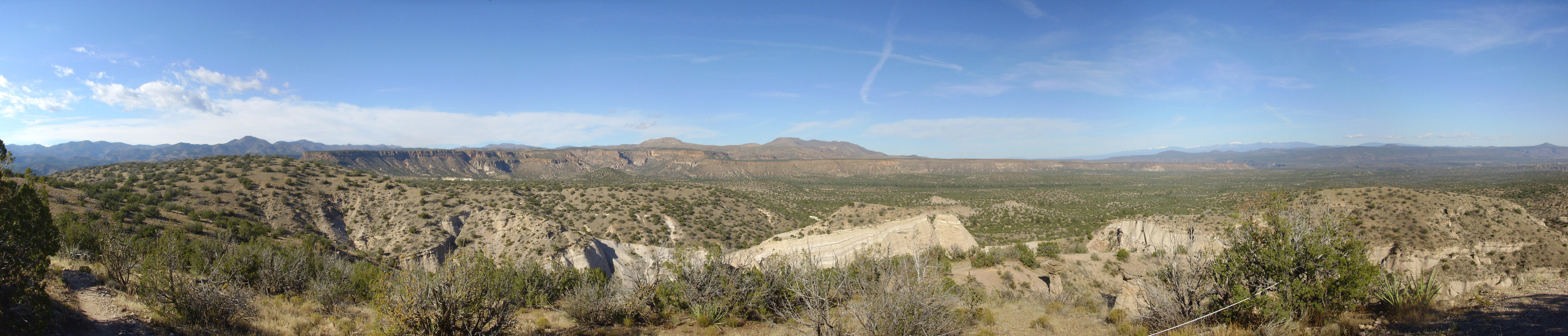
The peak on the skyline at left is Bearhead Peak, a major eruptive center of the Bearhead Rhyolite. The cliffs in the middle distance are Bandelier Tuff. At center is the San Miguel Mountains; the peak left of center is Cerro Balitas while Cerro Picacho is located nearly at the center of the panorama, superimposed on St. Peters Dome. At far right is the Cerros del Rio Plateau.
Of particular interest is the fault escarpment in the Bandelier Tuff, located squarely between Cerro Balitas and Cerro Picacho. (Click to enlarge.) This is the trace of the Pajarito Fault, which throws down the beds to its east. It turns southwest to lose itself in the maze of north-south faults of the Cochiti Fault Zone, west of where I’m standing. The Bajada Fault I photographed earlier runs along the face of the Cerros del Rio to the east. Kashe-Katuwe is located on a sort of point between the two faults, thrown down relative to both. It is this location on low ground, which is subsiding due to fault movement, that has preserved such great thicknesses of Peralta Tuff.
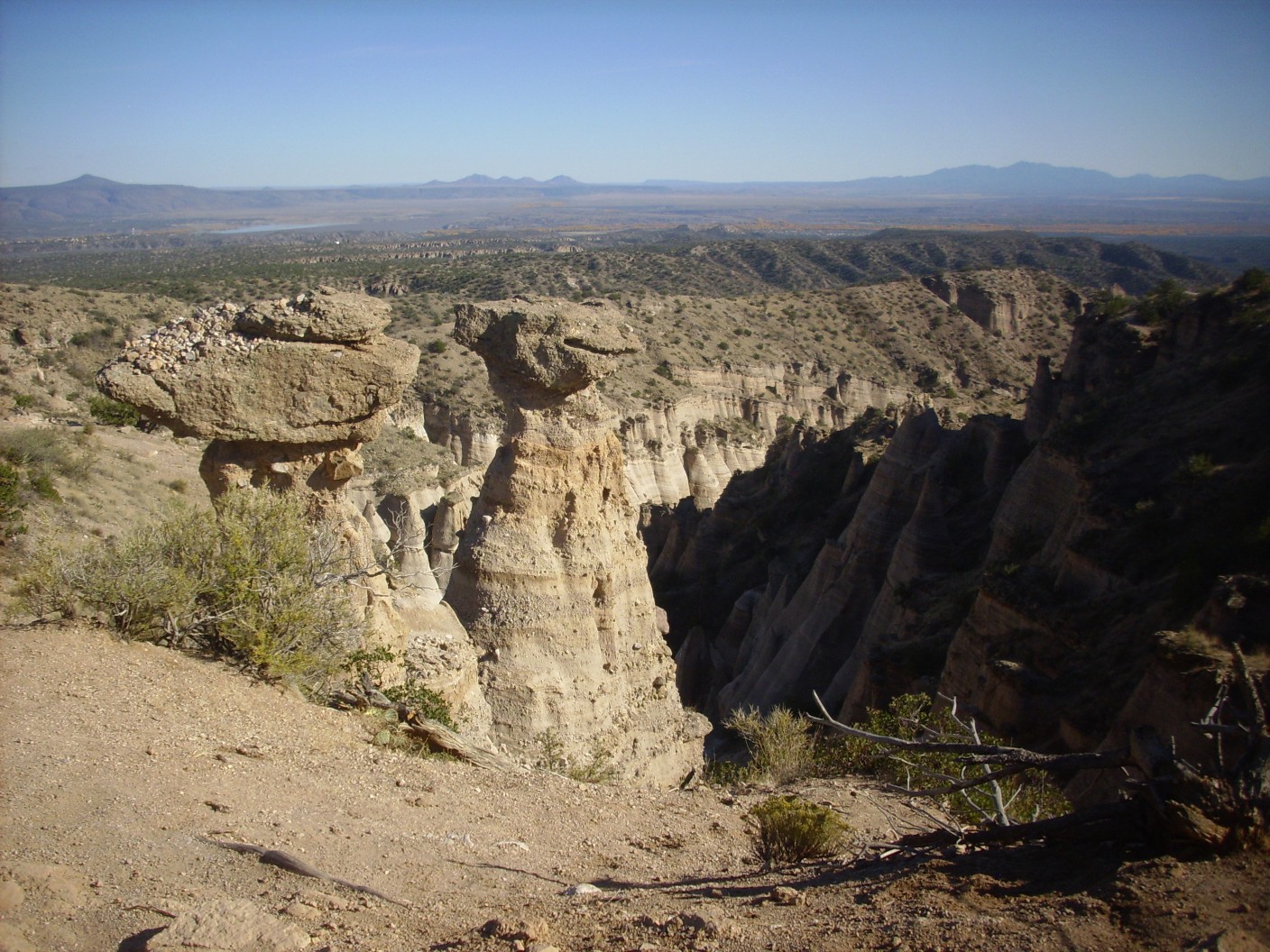
A view into the slot canyon.
Notice the slump right of center, where beds have come loose and slid downhill slightly before coming to rest again. I should not wish to be in the slot canyon if the beds cut loose a second time.
The ranger starts to chivvy us.
“This is my second time here. The first time I got chased out by the ranger before I could reach the top.”
“You’d think you’d have learned to come earlier in the day.”
“Well, I made it to the top this time, didn’t I?”
“Trooth.”
Or so a fellow hiker dubbed the two pillars next to the trail. The ranger was amused. I think the names may stick.
The ranger informs us that the pillar at left has a barrel cactus on top, almost buried under the gravel, that blooms beautifully each spring. The pebbles are apparently the work of earlier tourists on the trail, alas.
From there, back through the slot canyon, to my car, and home. I am running just a touch behind; the 25 MPH speed limit exiting the park seems to crawl. But I get home in time to take Cindy to dinner in celebration of her (mumble mumbleth) birthday.
There are lots of computer algorithms that look for faces in pictures. The “Deep Dreaming” algorithm is one that is “forced” to find faces even if they aren’t there. The results are disconcerting when applied to Kashe-Katuwe Tent Rocks
https://www.americanscientist.org/sites/americanscientist.org/files/2015106118211426-2015-11HayesF1.jpg
That’s kind of unsettling.
But it would be interesting to see the algorithm applied to Fred and Wilma.